Heat Becomes the Main Weather Story Next Week
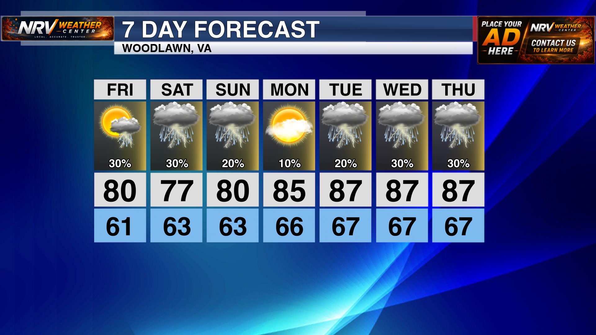
After a seasonable and occasionally unsettled weekend, a significant stretch of late-summer heat will build across Southwest Virginia and northwestern North Carolina next week. Temperatures will begin climbing Sunday, with the hottest conditions currently expected from Monday through Wednesday.
The intensity of the heat will vary considerably across the region. Higher-elevation communities including the NRV and North Carolina mountains, will generally remain in the 80s. Lower elevations and locations east of the Blue Ridge will be considerably hotter, with highs reaching the middle and upper 90s in some communities.
Humidity will make the heat feel even more uncomfortable. By Wednesday, peak heat index values may approach 100 degrees in parts of the Roanoke Valley and North Carolina foothills and Piedmont. Although the forecast will continue to be refined, now is a good time to prepare for several consecutive hot and humid afternoons.
Friday and Saturday: Storm Chances and Cooler Temperatures
The heat wave will not arrive immediately. Scattered showers and thunderstorms remain possible Friday and Saturday, with temperatures consistent in the 80s. Coverage will not be constant, but any thunderstorm could produce locally heavy rain, frequent lightning and gusty winds.
Clouds and scattered storms should keep temperatures lower through Saturday, but humidity will remain noticeable.
Sunday: The Warming Trend Begins
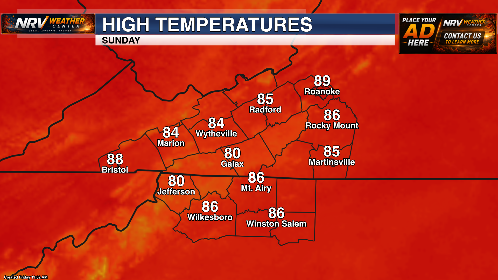
Sunday will mark the beginning of the warming trend. Forecast highs put most of the region in the low to mid 80s. Roanoke and Bristol could approach the upper 80s, along with communities in the NC piedmont.
An isolated shower or thunderstorm remains possible, but Sunday should serve as the transition into the hotter pattern expected early next week.
Monday: Heat Expands Across the Region
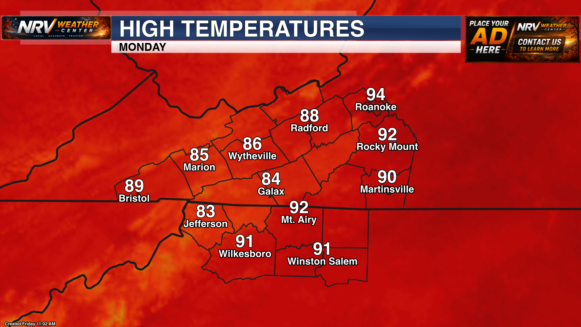
Monday is when the heat becomes much more noticeable. Forecast highs include the middle 80s across Galax, Marion and Wytheville; the upper 80s in Radford and Bristol; and the lower to middle 90s around Roanoke, Rocky Mount and Mount Airy.
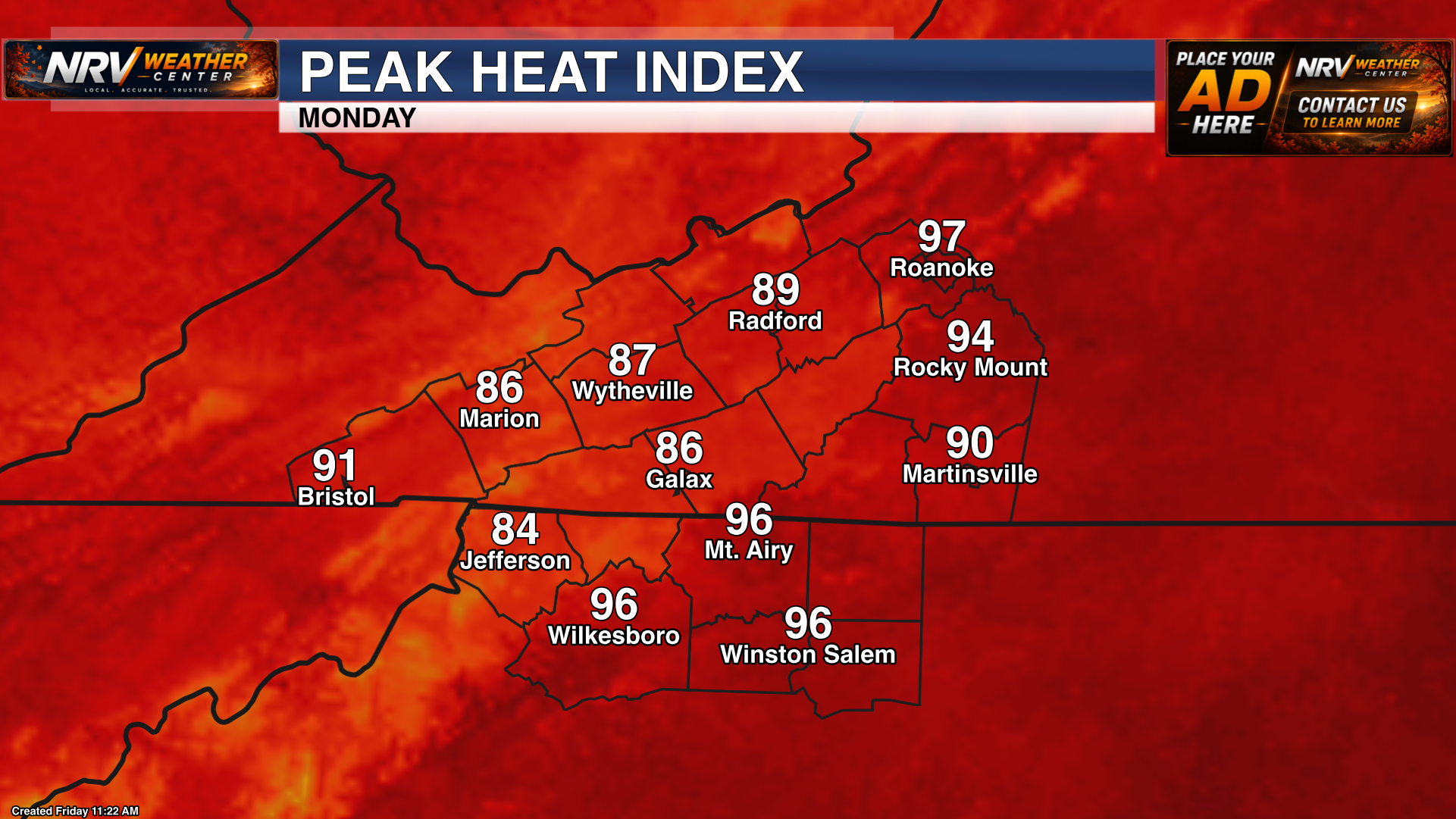
Humidity will push peak heat index values above the actual air temperature in many locations. Current projections suggest it may feel like the middle to upper 90s around Roanoke, Rocky Mount, Mount Airy, Wilkesboro and Winston-Salem. Farther west and in the higher elevations, heat index values are forecast to remain mainly in the middle 80s to around 90 degrees.
Monday currently appears to offer the lowest rain chance of the period, allowing more sunshine and helping temperatures climb quickly during the afternoon.
Tuesday: Widespread Heat Continues
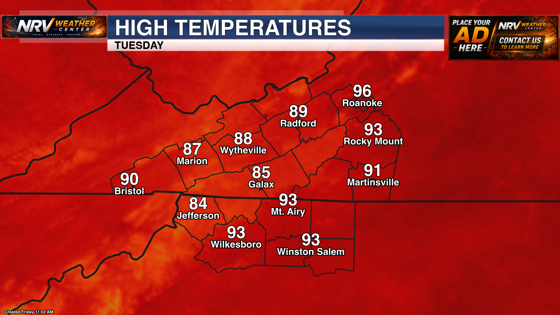
Tuesday will bring another hot afternoon, with temperatures similar to or slightly warmer than Monday. Highs are forecast to reach the middle and upper 80s across the mountains and New River Valley, while Roanoke could approach 96 degrees. Lower to middle 90s are expected from Rocky Mount and Martinsville southward into the North Carolina foothills and Piedmont.
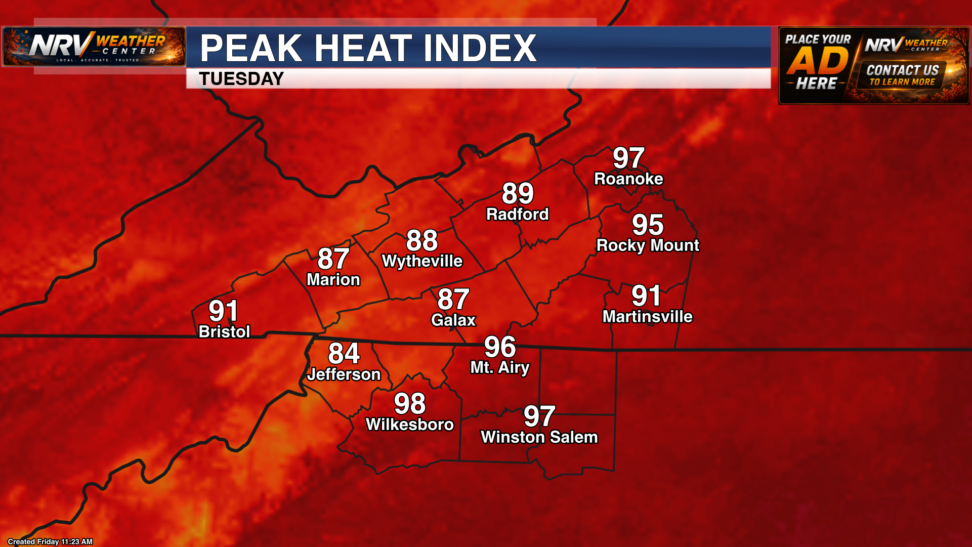
Peak heat index values may reach the upper 90s around Roanoke, Mount Airy, Wilkesboro and Winston-Salem. Even where the heat index remains in the upper 80s or lower 90s, the combination of several hot afternoons and increasingly warm nights can place additional stress on people without dependable air conditioning.
An isolated afternoon or evening thunderstorm is possible. Any storm could provide brief cooling, but most of the day will remain hot and humid.
Wednesday: Potential Peak of the Heat Wave
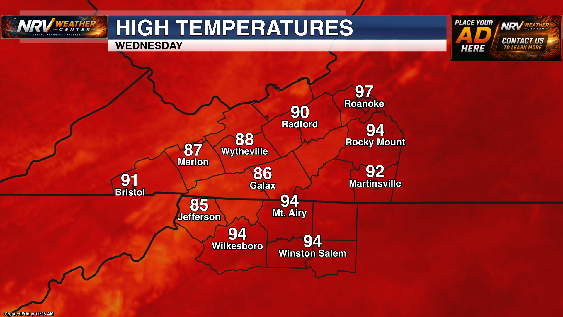
Wednesday currently appears to be the hottest day of the stretch for many communities. Forecast highs range from the middle and upper 80s across Galax, Jefferson, Marion and Wytheville to around 90 degrees in Radford. Roanoke could reach the upper 90s, while Rocky Mount, Martinsville, Mount Airy, Wilkesboro and Winston-Salem are forecast to reach the lower to middle 90s.
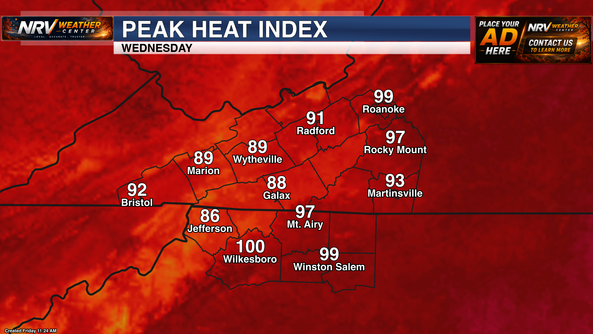
The heat index could approach 100 degrees around Roanoke, Wilkesboro and Winston-Salem, with upper 90s possible around Rocky Mount and Mount Airy. Wednesday therefore has the greatest potential for heat-related impacts, particularly for anyone working outdoors, practicing or playing sports, or spending a long period in direct sunshine.
Scattered afternoon or evening thunderstorms may develop. Storm coverage and timing remain uncertain this far in advance, so storms should not be counted on to provide meaningful relief everywhere.
Thursday and Beyond: Heat May Continue, but Details Are Less Certain
Temperatures may remain well above normal Thursday, with another afternoon in the middle or upper 80s around Woodlawn and hotter conditions in the valleys and Piedmont. Scattered showers and thunderstorms may become somewhat more common, but the exact timing of any cold front—and how quickly meaningful relief arrives—remains uncertain.
The forecast beyond Wednesday is still subject to change. Small differences in cloud cover, thunderstorm coverage and humidity could have a noticeable effect on both high temperatures and peak heat index values.
Preparing for Several Days of Heat
This is expected to be a multi-day heat event rather than a single hot afternoon. The repeated exposure and limited overnight cooling may create problems even in communities where temperatures remain below 100 degrees.
- Drink water regularly, even before you feel thirsty.
- Limit strenuous outdoor activity during the hottest part of the afternoon when possible.
- Take frequent breaks in shade or air conditioning.
- Never leave children or pets in a parked vehicle.
- Check on older adults, neighbors and anyone without reliable air conditioning.
- Make sure outdoor pets have constant access to fresh water and shade.
- Watch for signs of heat exhaustion, including heavy sweating, weakness, dizziness, nausea and headache.
Forecast temperatures and heat index values will be adjusted as new information becomes available. NRV Weather Center will continue tracking the heat, humidity, daily storm chances and the timing of eventual relief throughout the weekend and early next week.